About 4WD Maps - Offline Topo Maps
The original Hema app, popular and highly rated by adventurers in Australia since 2011. Includes the latest 2022 maps. Best value Hema App. The one-time cost includes all Hema 4WD maps, without any recurring subscriptions.
The original Hema app, popular and highly rated by adventurers in Australia since 2011. Includes the latest 2022 maps.
Best value Hema App. The one-time cost includes all Hema 4WD maps, without any recurring subscriptions.
Use offline mapping and your device’s in-built GPS receiver to see where you are on detailed Hema maps, which feature roads, 4WD tracks, topographic information and POIs to guide your travels off the beaten track.
NAVIGATE OFFLINE
Find your location
Real-time GPS tracking*
Australia-wide map coverage
Simple zooming
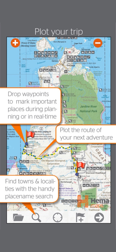
PLOT YOUR TRIP
Drop waypoints
Plan routes
Placename search
SAVE & RECORD YOUR TRACKS
Record your trips
Create tracklogs
Save tracks with information
Share tracklogs & waypoints
ACCESS HEMA'S PREMIUM MAP COLLECTION
The app comes preloaded with a massive library of Hema touring and 4WD maps that covers all of Australia:
Base Maps:
Australia 1:250K TOPO
Hema Explorer Map at 1:150,000 - 1:10M
Goldfields-Esperance - Cape Arid NP
Goldfields-Esperance - Cape Le Grand NP
Cape York - The CREB Track
Cape York - Lakefield NP
Cape York - The Tip
Goldfields-Esperance - Fitzgerald River NP
Flinders - Flinders Ranges Mainmap
Flinders - Mount Remarkable NP
Flinders - Flinders Ranges NP
Flinders - Vulkathunha Gammon Ranges NP
Fraser Island - Central Station
Fraser Island - Mid Fraser
Fraser Island - Rainbow Beach
Great Desert Tracks - North Central
Great Desert Tracks - North East
Great Desert Tracks - North West
Great Desert Tracks - South Central
Great Desert Tracks - South East
Great Desert Tracks - South West
Goldfields-Esperance and Southern Coast of WA
Goldfields-Esperance Region
High Country Victoria East
High Country Victoria West
Top End - Kakadu National Park
Outback NSW - Kinchega NP
Sth West Corner - Margaret River Wine Region
Mid West Western Australia
Mid West WA - Francois Peron NP
Mid West WA - Kalbarri NP
Mid West WA - Kennedy Range NP
Mid West WA - Mount Augustus NP
Outback NSW - Mungo NP
Outback NSW - Mutawintji NP
Outback New South Wales
Outback Queensland
Outback QLD - Bladensburg NP
Outback QLD - Carnarvon Gorge
Outback QLD - Currawinya NP
Outback QLD - Diamantina NP
Outback QLD - Idalia NP
Outback QLD - Mt Moffat
Outback QLD - Salvator Rosa and Ka Ka Mundi
Pilbara
Pilbara - Cape Range NP
Pilbara - Karijini NP
Pilbara - Millstream Chichester NP
Pilbara - Rudall River Karlamilyi NP
Simpson Desert 1:1,100,000
Simpson Desert 1:500,00
South West Corner - 200k
South West Western Australia
Goldfields-Esperance - Stirling Ranges NP
Goldfields-Esperance - Stokes NP
Outback NSW - Sturt NP
The Kimberley
The Kimberley - Dampier Peninsula
The Kimberley - Purnululu NP
The Kimberley - Wyndham-Kununurra
The Red Centre
Top End and Gulf - Boodjamulla NP
Top End and Gulf - Darwin Region
Top End and Gulf - Gregory NP
Top End and Gulf - Keep River NP
Top End and Gulf - Nhulunbuy
DOWNLOAD ADDITIONAL MAP SOURCES
Access a wide range of additional map sources which are available for purchase via the Memory-Map Digital Map Shop.
USE ON WINDOWS PC or MAC
Use the same maps and overlays on your desktop/laptop to plan your route and review tracklogs. (Maps sold separately).
*You do not need a SIM Card installed or cellular coverage to utilise the GPS tracking functions on iPad for the app, though a WiFi+Cellular iPad is necessary to discover and track your location. A WiFi-only iPad does not contain the in-built GPS that a WiFi+Cellular iPad does, however external Bluetooth GPS receivers can be purchased for use with a WiFi-only iPad.
Sep 7, 2022
Version 2.4.2
Updated Maps: Great Desert Tracks & Simpson Desert
New Map: Nullarbor Plain
Easier to tap toolbar buttons on iPhone (swipe home twice to close the app)
Previous Versions
Here you can find the changelog of 4WD Maps - Offline Topo Maps since it was posted on our website on 2016-10-02 01:09:13.
The latest version is 2.4.2 and it was updated on 2024-04-22 08:43:28. See below the changes in each version.
4WD Maps - Offline Topo Maps version 2.4.2
Updated At: 2022-09-07
Changes: Sep 7, 2022
Version 2.4.2
Updated Maps: Great Desert Tracks & Simpson Desert
New Map: Nullarbor Plain
Easier to tap toolbar buttons on iPhone (swipe home twice to close the app)
4WD Maps - Offline Topo Maps version 2.4.1
Updated At: 2021-09-25
Changes: Sep 25, 2021 Version 2.4.1
Compatible with iOS15
Main-screen data boxes enhanced (tap-and-hold at edge of screen)
Display GPS range-rings (GPS Settings)
New Odometer data item (tap-and-hold to reset, pause or rename)
Access overlays list from main screen toolbar
Improved many dialog layouts
4WD Maps - Offline Topo Maps version 2.4.0
Updated At: 2021-03-27
Changes: Mar 27, 2021 Version 2.4.0
New detailed maps of High Country Victoria
New State map series covering all Australian States
New detailed map of Landcruiser Mountain Park, QLD
New Software features: Tap a track to select/edit
Find Time, Speed and Altitude at any point on the track
Split & Join Routes and Tracks
4WD Maps - Offline Topo Maps version 2.3.2
Updated At: 2020-07-23
Changes: Jul 23, 2020 Version 2.3.2
Extended Route Optimization limit to 500km
Bug fixes
4WD Maps - Offline Topo Maps version 2.3.2
Updated At: 2020-07-23
Changes: 23 Jul 2020 Version 2.3.2
Extended Route Optimization limit to 500km
Bug fixes
4WD Maps - Offline Topo Maps version 2.3.1
Updated At: 2020-02-25
Changes: Feb 25, 2020 Version 2.3.1
Many new and updated maps, including:
The Red Center
Flinders Ranges
GDT
Pilbara
Simpson Desert
The Kimberly
QLD Top End
South West WA
New programmable buttons on the Nav data page
Bug Fixes
4WD Maps - Offline Topo Maps version 2.2.2
Updated At: 2019-04-18
Changes: Apr 18, 2019 Version 2.2.2
New Hema Explorer maps & updated 4WD maps
Much faster add-on map downloads
Works with system network proxy setup
Map list uses expanding tree view instead of Map Types button
Layout works with iPhone X, etc
Support for Barometer / Altitude
A few bug fixes
Topo250 provided as an optional download to reduce download time
4WD Maps - Offline Topo Maps version 2.1.0
Updated At: 2011-11-22
4WD Maps - Offline Topo Maps version 2.3.2
Updated At: 1970-01-01
Changes: 23 de jul de 2020 Version 2.3.2
Extended Route Optimization limit to 500km
Bug fixes
4WD Maps - Offline Topo Maps version 2.3.1
Updated At: 1970-01-01
Changes: 2020年2月25日 Version 2.3.1
Many new and updated maps, including:
The Red Center
Flinders Ranges
GDT
Pilbara
Simpson Desert
The Kimberly
QLD Top End
South West WA
New programmable buttons on the Nav data page
Bug Fixes